ビザンツ帝国のレオーン三世と当時のキリキア情勢
私事であるが中国人の世界史マニアと知り合いになり、時折wechatにて彼と日中両言語を交えて世界史談義をするようになった。
その中で彼がビザンツ帝国皇帝レオーン三世について熱く語っていたので調べてみた。以下その際に私が調べたことをまとめたものである。
-------------------------------------------------------------------------------------------------
レオーン三世またはレオ三世と呼ばれるビザンツ皇帝は、そう、『ギリシャの火』でイスラム勢を追い払った皇帝といえばわかるだろう。ギリシャの火とはギリシャ・ローマ文明が作った中世のハイテク兵器であって、ウマイヤ朝の軍隊がビザンツ帝国のコンスタンティノープルを包囲したときこれによって彼らを撃退したのである。そしてその時のビザンツの皇帝がレオーン三世であった。
===============
ギリシャの火に関しては以下参照
===============
レオーン3世が活躍したヘラクレイオス王朝からイサウロス王朝時代は東ローマ帝国が地中海の覇権国家からギリシャ、アナトリアの地域国家へと転落していくプロセスである。この時代、アラブ勢力によりシリア、北アフリカが侵略される。
レオーンの出身地であるゲルマニケイア(現在のカフラマンマラシュ)はアナトリア、シリア境界地域にあり、その地域は東ローマとアラブの係争地域となっていく。
以下、レオーン3世出身地の調査を通して、ヘラクレイオス王朝からイサウロス王朝時期のアナトリア、シリア境界地域について考察する。
1.レオーン三世の青年期
Wikipedia日本語版によると、青年時代のレオ3世はコノンと名乗っており、ゲルマニケイア出身でユスティニアノス二世の植民政策でトラキア(今のブルガリアのあたり)に移住している。
この情報によると、コノンがトラキアに移住したのは690年代から700年代頃ということになる。
レオ3世のその後の活躍に関してはいくらでもネットに書かれているであろうから、我々はそこには注目せず、コノンがレオ3世となるまでをどのように過ごしたのかについて注目したい。
そしてそのために、コノンが生まれ育った7世紀、8世紀のアナトリア、シリア境界地域について調べ、そこからコノンがレオ3世となった背景を想像しようと思う。
2.当時のキリキアとゲルマニケイア
そこで、本論では当時のゲルマニケイア(現在のカフラマンマラシュ)周辺の情勢について述べる。
当時、シリアとアナトリアにおけるアラブとビザンツ境界線地域をアラビア語ではスグールthughurといった。al-thughūr (اَلـثُّـغُـوْر; sing. al-thagr, اَلـثَّـغْـر, "cleft, opening")
以下本論ではその地域をアラブ・ビザンツ フロンティアゾーンと呼ぶ。
この地域はかなり特殊な地域であったらしく一見に値する。以下、wikipedia 英語版記事“Al-ʿAwāṣim”の内容を転記する。転記は一文ずつ転記し、その下に私の日本語による概要を加える。
Al-ʿAwāṣim (Arabic: العواصم, "the defences, fortifications"; sing. al-ʿāṣimah, اَلْـعَـاصِـمَـة, "protectress") was the Arabic term used to refer to the Muslim side of the frontier zone between the Byzantine Empire and the Umayyadand Abbasid Caliphates in Cilicia, northern Syria and Upper Mesopotamia.
アル=アワスィムはアラブ・ビザンツ フロンティアゾーンのアラブ側の呼称である。それはキリキア、北メソポタミア、シリアにあった。
[2] It was established in the early 8th century, once the first wave of the Muslim conquests ebbed, and lasted until the mid-10th century, when it was overrun by the Byzantine advance.
それは八世紀初めに成立し、10世紀まで存在した。
It comprised the forward marches, comprising a chain of fortified strongholds, known as al-thughūr (اَلـثُّـغُـوْر; sing. al-thagr, اَلـثَّـغْـر, "cleft, opening"), and the rear or inner regions of the frontier zone, which was known as al-ʿawāṣim proper.
その前方は一連の要塞からなっており、al-thughurと呼ばれた。そして、アラブ ・ビザンツ フロンティアゾーンの後背地や内陸部の地域はアル=アワスィムと呼ばれた。
On the Byzantine side, the Muslim marches were mirrored by the institution of the kleisourai districts and the akritai border guards.
ビザンツ側ではアワスィムやスグールに対して、クレイソーライκλεισούραとアクリタイἀκρίταιが設けられた。
In the Byzantine Empire, a kleisoura (Greek: κλεισούρα, "enclosure, defile") was a term traditionally applied to a fortified mountain pass and the military district protecting it.[1] By the late 7th century, it came to be applied to more extensive frontier districts, distinct from the larger themata, chiefly along the Empire's eastern border with the Caliphate along the line of the Taurus-Anti-Taurus mountains (in the West, only Strymon was in its early days termed a kleisoura).[1]
https://en.wikipedia.org/wiki/Kleisoura_(Byzantine_district)
クレイソーラは要塞化された山道、またはそれを守るための軍区である。(wikipedia “Kleisoura”より抜粋)
The Akritai (Greek: ἀκρίται, singular: Akritēs, ἀκρίτης) is a term used in the Byzantine Empire in the 9th–11th centuries to denote the army units guarding the Empire's eastern border, facing the Muslim states of the Middle East. Their exploits, embellished, inspired the Byzantine "national epic" of Digenes Akritas and the cycle of the Acritic songs.
https://en.wikipedia.org/wiki/Akritai
アクリタイはビザンツとアラブの境界地域で国境を守る舞台のこと。彼らの活動はアクリタイの歌と言われる一連の叙事詩を生み出し、その中でも特に有名なものがDigenes Akrites (Greek: Διγενῆς Ἀκρίτης, pronounced [ðiʝeˈnis aˈkritis])と呼ばれる叙事詩である。
(wikipedia “Akritai”より抜粋)
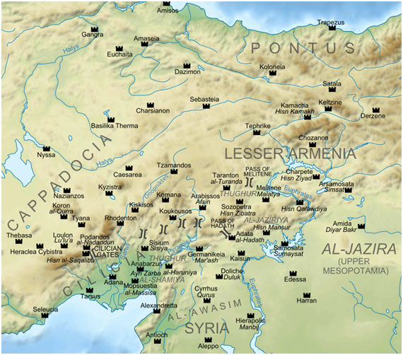
(地図を見るとAL-AWASIM や THUGHURといった文字が見られ、アラブ寄りの平野がアル・アワスィム、より北側の山間部がスグールであることが見て取れる。wikipedia 英語版記事“Al-ʿAwāṣim”)
(以下、またwikipedia “Al-ʿAwāṣim”より)
Already from late 630s, after the rapid Muslim conquest of Syria, a wide zone, unclaimed by either Byzantines or Arabs and virtually deserted (known in Arabic as al-Ḍawāḥī (اَلـدَّوَاحِي, "of the Outer Lands") and in Greek as ta akra (τὰ ἄκρα, "the extremities") emerged between the two powers in Cilicia, along the southern approaches of the Taurus and Anti-Taurus mountain ranges, leaving the Anatolian plateau in Byzantine hands.
アラブのシリア征服以降の630年代からビザンツ とアラブのどちらにも属さない、実質砂漠化した広大な地域がキリキア地方に現れた。この砂漠はアラビア語ではal-Ḍawāḥī (اَلـدَّوَاحِي, "外側の土地") 、ビザンツ のギリシャ語ではta akra (τὰ ἄκρα, "最果て") とよばれた。この地域はキリキア地方のそれもタウルス山脈やアンチタウルス山脈の南側に沿った地域に存在していた。アナトリアはまだビザンツ側に属していた。
Both Emperor Heraclius (r. 610–641) and the Caliph ʿUmar (r. 634–644) pursued a strategy of destruction within this zone, trying to transform it into an effective barrier between their realms.[2][4]
ビザンツのヘラクリウス帝(610-641)もカリフ・ウマルもこの地域を破壊する政策を継続し、この地域を両国の緩衝地帯(effective barrier)にしようとしていた。
Nevertheless, the ultimate aim of the caliphs remained the outright conquest of Byzantium, as they had done with its provinces in Syria, Egypt and North Africa, and it was only the failure of the Second Arab Siege of Constantinople in 717–718 that forced a revision of this strategic objective:
しかしカリフの最終目的はビザンツの征服であった。だが、第二次コンスタンティノープル包囲戦の失敗で、その政策は方向転換を強いられた。
although raids into Anatolia continued, the goal of conquest was abandoned, and the border between the two powers began to acquire more permanent features. For the next two centuries, border fortresses might change hands between Byzantines and Arabs, but the basic outline of the Arab–Byzantine border remained essentially unaltered.[5][6][7]
アナトリア侵攻は続いたがビザンツ征服の最終目的は廃止された。そのことで、両国の境界線地域はより永続的なものとなった。
Thus the term al-thughūr, which initially meant "fissures, clefts" (cf. their Greek name ta Stomia, τὰ Στόμια, "the mouths/openings") and designated the actual borderlands, came to mean "boundaries", employed in phrases like Thughūr al-Islām (ثُـغُـوْر الْإِسْـلَام, "Boundary of Islam") or Thughūr al-Rūmīya (الـثُّـغُـوْر الـرُّوْمِـيَّـة, "Boundary of the Romans").[2][8][9]
このスグールal thughurという単語は「裂け目」という意味であり(ギリシャ語では「口」を指す τὰΣτόμια(ta stomia)という名前で呼ばれた)、実質的に国境となった。
https://en.wikipedia.org/wiki/Al-Awasim
3.以上を踏まえて
このように、コノンが生まれた頃のゲルマニケイア周辺はビザンツ とアラブの抗争により要塞が立ち並び、荒廃して砂漠の広がる地域だったようだ。
Wikipedia『レオーン3世』の記事における、トラキアへの移住がどういう流れで起きたのかは分からずじまいだったが、荒廃して砂漠化しまともに生活もできなさそうな場所なので(a wide zone, unclaimed by either Byzantines or Arabs and virtually deserted ;Wikipedia “Al-ʿAwāṣim”より)、ユスティニアノス2世がビザンツ ・アラブ フロンティアゾーンの住人をトラキアに移住させたか(ユスティニアノス2世はこの地域を破壊する政策を遂行したと記事にもある)、またはブルガール族に備えて屯田兵のようなことをさせたのかもしれない。
この辺りは、テマ制について詳しくないと多くは語れないのでこの辺りで話をおこうと思うが、とにかくユスティニアノス2世からレオーン3世の時代は東ローマが地中海の覇権国家からギリシャ・アナトリアの地域国家ビザンツに変わっていくプロセスであった、そして、この時代の政策も、レオーン3世の青年時代も、キリキア地方の混沌とした情勢にもそうした覇権国家から地方政権への凋落が現れていたということができるだろう。
コノンがレオーン3世となったのも、このような混沌とした時代情勢や生育環境のなかで揉まれてきたことは見落とすことができないであろう。
見逃してはならないのは、ゲルマニケイアがコノンが生まれる以前にアラブにより陥落されているということ。
Wikipedia kahraman marash
In 645, Germanicia was taken from the Byzantines by the Muslim Arabs, to whom the city was known as Marʿash (Arabic: مرعش [ˈmarʕaʃ], which is also the Syriac ܡܪܥܫ). Marash was an important Syriac Orthodox diocese
645年にゲルマニケイアはアラブ軍に奪われ、マラシュと名前を改められた
恐らく彼が生まれた頃は、ゲルマニケイアもビザンツに落とされたり、アラブに落とされたりを繰り返している状態だったのではなかろうか。そうでなければゲルマニケイア陥落の40年後、685年生まれのコノンがユスティニアノス2世の政策でトラキアに移住したことの説明がつかない。
当時のゲルマニケイアはビザンツになったり、アラブになったりする地域であり、場合によってコノンもウマイヤ朝の臣民になっていた人生もあり得たのかもしれない。